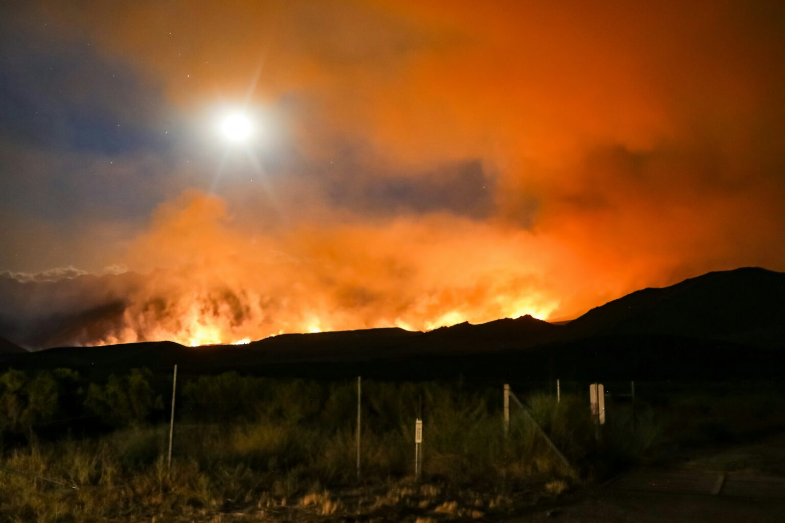
Wildfires. Uncontrolled infernos that can span tens, hundreds, or even thousands of square kilometres. Fuelled by anything remotely flammable that they connect with, be it forests, croplands, or buildings, to name a few.
In the US alone, individual wildfire seasons have inflicted damages up to $30 billion (inflation-adjusted to 2024 USD).
At the time of writing, 2025 has barely begun, but already wildfires have left a terrible legacy in and around the famous city of Los Angeles, California.
Alongside the tragic fatalities and damage or destruction of properties, hundreds of thousands have seen interruptions to their power supply, and poor air quality has led to health concerns across much of the Los Angeles metro area.
Speaking on CNN, climate scientist Daniel Swain voiced an expectation that these fires will amount to the costliest wildfire event on record. This has a sound basis, with California housing some of the most expensive real estate in the country. Severe fires in the state are the main reason for 2018 holding the record for the costliest US wildfire season.
Trigger Conditions
Two of the strongest drivers of high wildfire risk are low vegetation moisture content and strong winds. The first of these is highly intuitive – branches, twigs, and grasses ignite far more readily when tinder-dry than when freshly moisturised. The second merits some elaboration.
You might wonder why strong winds don’t simply blow out a fire, like when you huff on a lit match or candle. The short answer is, because wildfires cover much larger areas than candles or matches, the effect of strong winds on them is akin to fanning a fire, in other words stoking it.
The longer answer is that when we blow on a flame, we’re actually helping it out up to a point, by increasing the rate of supply of oxygen, but we also impart a cooling effect on the lit object. If we blow hard enough, the cooling effect outweighs the increased oxygen supply and out goes the flame. With wildfires, the ratio of very hot burning matter to cooling effect of airflow is much higher and as such, increasing the wind speed mainly helps a wildfire out.
Not only does windy weather aid wildfire intensity and longevity, it also ups the rate of spread, as burning embers travel more rapidly and reach greater distances. This also makes wildfires more difficult for firefighters to contain.
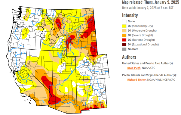
Last year began unusually wet in California, leading to enhanced vegetation growth, only for the hottest summer on record to trigger a rapid descent into drought. This succession pushed potential tinder-dry vegetation coverage well above normal.
8th January 2025 saw the onset of severe ‘Santa Ana’ winds, blowing toward the coast with gusts reaching up to 100 mph.
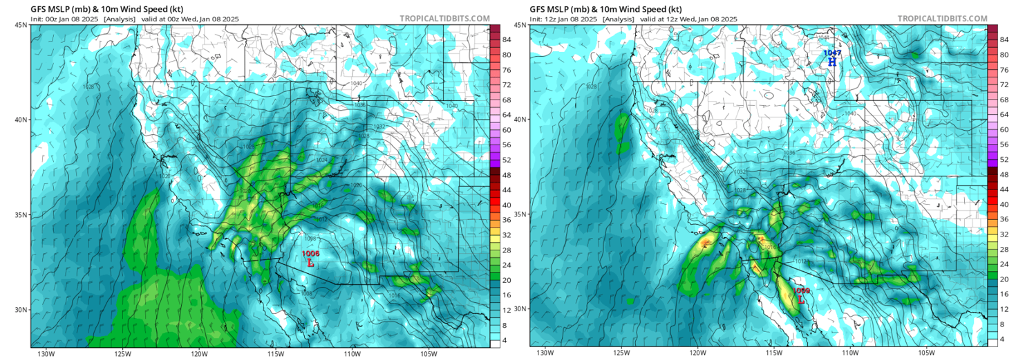
What’s more, the air accelerated over Southern Nevada and then headed southwest, crossing an area of extreme drought conditions, before reaching the highly populated Californian coastal region. For wildfires in this area, it’s hard for the situation to become any more conducive than that.
Do We Blame Climate Change?
In short, not directly. It didn’t cause this weather pattern to take shape, or even the current drought to be ongoing. That’s generally not how climate change impacts work.
Instead, long-term frequency and intensity trends must be considered. When it comes to the Santa Ana winds, the wind speed aspect has no known significant trend, but the dry vegetation state does.
Put simply, temperatures have been trending upward, increasing the evaporative demand (‘thirst of the atmosphere’), leading to more intense droughts. This is the conclusion of a recent NOAA study on western US droughts. Not only that, but high temperatures have recently taken over from low rainfall as the primary driver behind drought intensification.
With higher evaporative demand, moisture is extracted more quickly from vegetation, increasing the propensity for a tinder-dry state that readily ignites. In California, such drying out typically occurs for part of the year, but higher temperatures are increasing the duration of critically dry vegetation state, causing it to overlap ever-more with the time of year when strong land-to-coast winds tend to occur most (Oct-Jan).
Therefore, what could be called ‘critically dry Santa Ana winds’ are occurring more often.
Foreseen Risk
This tendency is considered by MetSwift’s predictive wildfire risk model, which leverages machine learning techniques to predict deviations in wildfire likelihood from a simulated 21st century to-date average. We say ‘simulated’ because the model uses known wildfire events and their associated weather plus geographical conditions to construct a climatology covering all areas, even where no historical wildfire information exists.
Importantly, the given risk is for escalation of any existing fire to a wildfire of at least 10,000 square km. This is because most fires that escalate to wildfires (potentially as much as 95%) are a result of human action (mainly lack of due care, but occasionally malicious), which is inherently unpredictable.
Our goal is to understand the predictable portion of the risk, to better anticipate when conducive human behaviour, such as tossing a smouldering cigarette into the scrub, are more liable to lead to a wildfire.
Shown below are what the December initialisation of this model predicted for the 2nd week of 2025 – first the predicted risk and then the deviation from the simulated climatology.
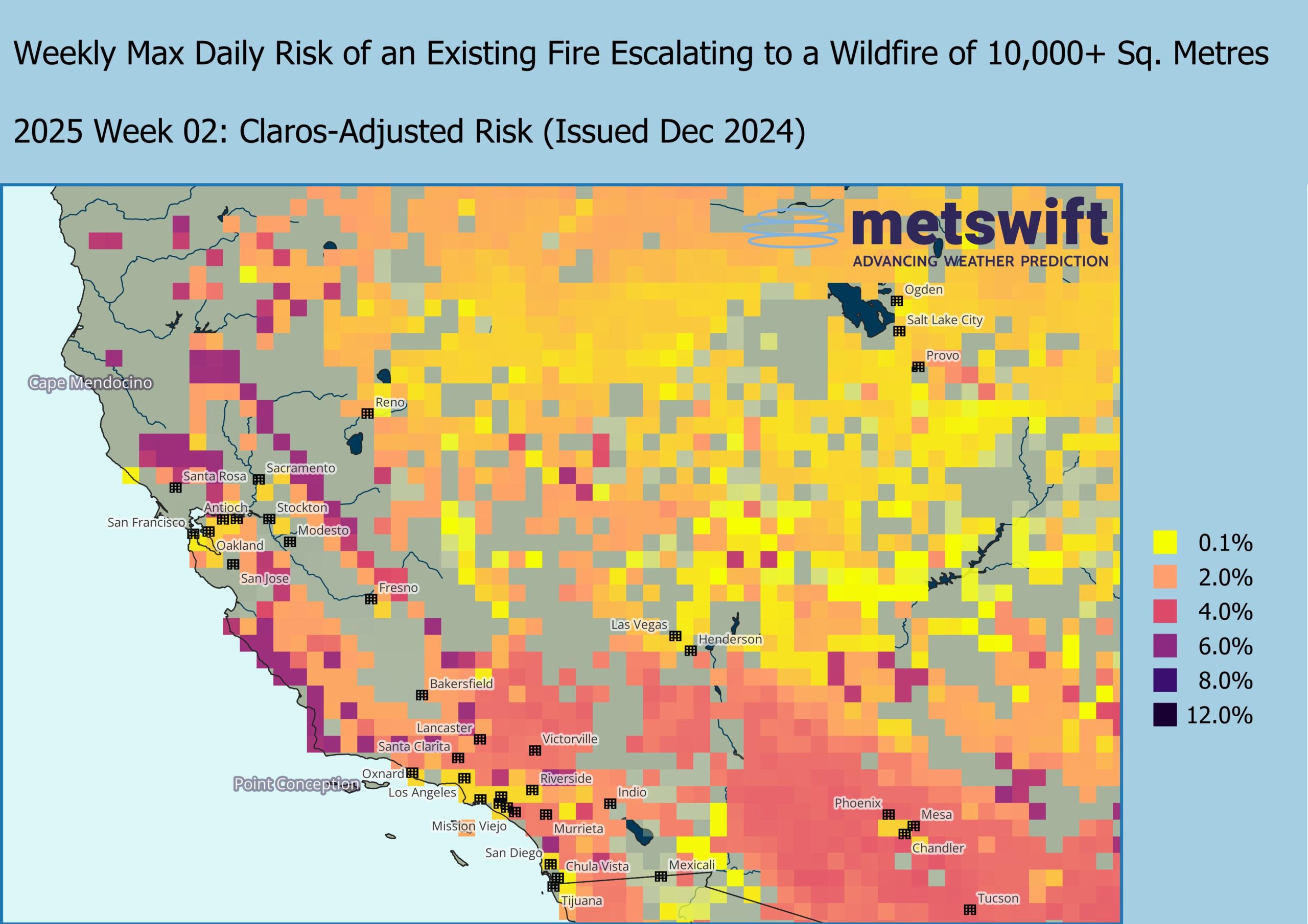
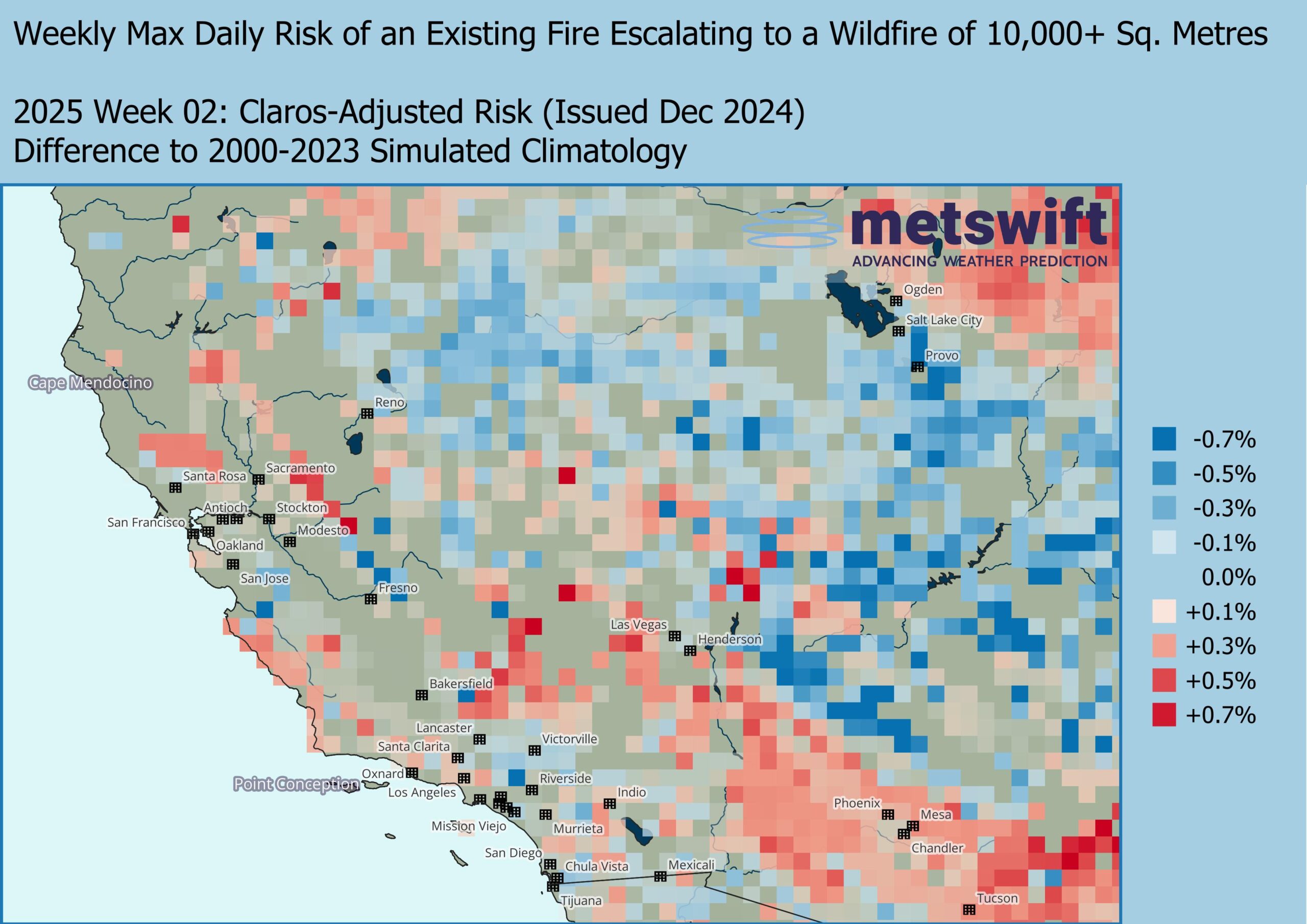
Notice that some of the highest risk areas are located not just in California, but in some of the most densely populated regions. This is typically the case – a risk long accepted by residents – but was predicted to be even more pronounced than usual across much of the state in week 2 of 2025.
Notably, that includes the areas of Pasadena in the north and Palisades/Santa Monica in the west of Los Angeles, both directly affected by the wildfires.
They’re within a swathe of higher than usual risk that extends well to the southeast. Widely 0.3 to 0.5% above the 2000-2023 averages of 2-5%. Proportionally, that’s some 5-10% higher. Such an increase across a wide area corresponds to a substantially higher likelihood that at least one location within experiences a wildfire.
Concerning Future Prospects
In the near-term at the time of writing, further dry weather with bouts of Santa Ana winds is forecast through to at least mid-month.
Much longer-term, depending on just how much future warming is predicted, studies have projected a 3 to 52% increase in the typical annual burned area within California by around 2050.
Not only is there a further increase in the average duration of critically dry vegetation, warmer air also has a higher moisture capacity. So, rainy spells of weather may deliver larger quantities of water, encouraging higher coverage of vegetation. More vegetation and more summer-autumn drying.
There’s also evidence that wildfires are tending to expand more quickly in the western US, the typical peak daily rate increasing by an eye-watering 249% between 2001 and 2020.
This dynamic natural catastrophe risk will need to be accounted for by residents and insurers alike.
James Peacock MSc
Head Meteorologist at MetSwift
Featured photo by Ross Stone on Unsplash
